


High Tech Radar Helps Safeguard Historic Burial Grounds
When the Washington Soldiers Home Cemetery in Orting decided to build a new road on its property it faced a dilemma—how to construct it without knowing exactly where all the burial sites are located?
In fact, one of the main difficulties of doing any construction around an historic cemetery or burial ground is knowing where it’s safe to work without disturbing graves. Often, precise records of such details weren’t kept back in the day.
Fortunately, CWU Anthropology and Museum Studies Professor Steve Hackenberger and his students can help. Hackenberger, working with teams of five or six students, utilizes high-tech locational equipment known as ground penetrating radar or GPR to find burial sites that may have been forgotten or overgrown.
The Soldiers Home Cemetery posed unique challenges because it is the final resting place for more than 2,200 veterans from the Civil War, Spanish American War, World War I, World War II, Korean War, and Vietnam War, including five Medal of Honor recipients. The historic cemetery was established in 1891.
“[Fortunately,] there was nothing that looked like a grave in the area where they want to construct the road,” Hackenberger said. “Because of a state law that protects graves, the [Washington] Department of Archaeology and Historic Preservation has been asking people to be extra careful with all work within cemeteries.”
Hackenberger said he was contacted because his team had been involved previously in similar projects, including at the historic Roslyn Cemetery, for the City of Cle Elum, and in assisting a local landowner to avoid disturbing an early historic mission site.
All of the work done by Hackenberger and his students is conducted through the Central Washington Anthropological Survey (CWAS). Under the direction of Josh Allen, CWAS performs archaeological investigations throughout the Pacific Northwest. Its goal is to enlist public involvement in identifying and protecting regional archaeological resources.
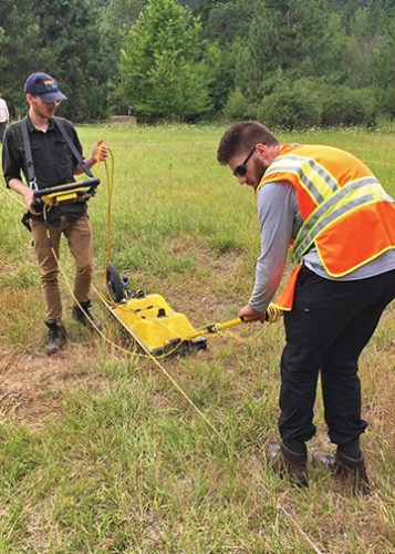
Summer field school students using the sled configuration for a Yakama Nation fisheries project.
Typically, rotating teams of students will work on each GPR survey project, with up to 20 students involved in some projects. The field work leads to computer data processing and imaging, and report writing. Students learn the theory, method, and technique of geophysics with hardware and software.
According to Allen, who has been overseeing the Soldiers Home Cemetery project, there is a growing need—including by state and federal agencies along with Native American tribes and nations—for the services CWU offers.
For example, Hackenberger and his team have been invited to work with the Puyallup Tribe to complete a GPR survey of a forested cemetery area. Washington State Parks has also reached out to Allen to help survey a sensitive area of coastal dune.
“By the end of the month, we’ll have student researchers and staff working on other GPR survey projects,” Allen said. “We’ll be looking to identify and document potentially unknown or unmarked grave sites.”
Hackenberger added that the true benefit to the type of work the students have been able to do is that it gives them real-world experience.
“The only way you can learn to use this is through hands-on,” he said. “Students get exposed at different levels. Even my introductory class learns about it and gets to use it. The software is really as interesting as the hardware.”
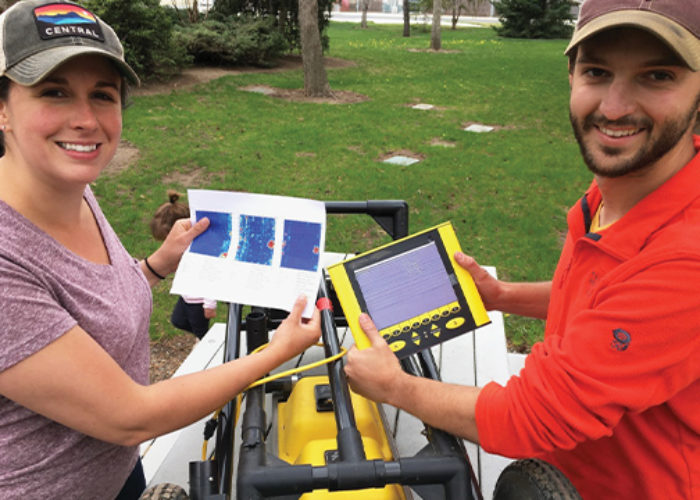
Mallory Triplett and Josh Allen display GPR results. The color map computer printout (left) shows a grave site in red. The GPR delta logger (right) provides a black and white radar profile of the grave site.
GPR Proves Beneficial in Many Fields
CWU undergraduate and graduate students from geology and geography also use the university’s GPR unit for research.
Students in the field methods in environmental geology class collect GPR data and apply their findings to topics that are of current interest in water resources management, as part of the Yakima Basin Integrated Water Management Plan.
Students have also used GPR to map the depth to groundwater on a gravel terrace along the Yakima River.
Karl Lillquist, a CWU geography professor, said his cultural and environmental resource management graduate students have been using GPR to assess the composition of rock glaciers in the Cascade Range. This work is aiding in understanding how much frozen water is actually held in those rock glaciers.
comments powered by Disqus